Routes
Road Ride Routes (PDF flyer)
100 Mile Route (actual is 100.5)
Route PDF | GPS Route
60 Mile Route (actual is 54.9)
GPS Route
47 Mile Route
GPS Route
El Pinto Red Hot Chile Ride, 25 Mile Route (actual is 23.1)
Route PDF | GPS Route
18 Mile (actual is 17.6)
GPS Route
12 Mile Rail Runner Family Ride
Route PDF | GPS Route
4K Fun Walk
Route PDF
Bone Shaker Gravel Grinder
17 Mile Route
34 Mile Route
50 Mile Route
ROUTE SPONSORSHIPS AVAILABLE FOR 100, 60, 47, 18 & 7 Mile Routes.
Contact Joanie Griffin at Sunny505 (505-261-4444)
ROUTE DESCRIPTION
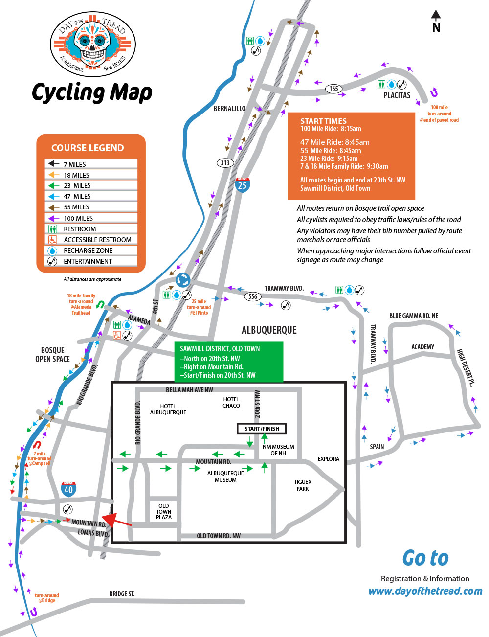
Day of the Tread routes leave the Sawmill District – Old Town, entering the historical neighborhoods and the Museum District.
The course then traverses along the flat terrain of the heavily wooded Bosque Trail Park and Rio Grande River for 7 miles, where fall colors can be viewed. Riders then approach the 'must stop at' legendary Recharge Zone at El Pinto Restaurant (turnaround for the 25 milers), where live music compliments the taste of sopaipillas and honey.
The riders quickly leave their urban surroundings and enter high desert landscape. As they approach the foothills of the Sandia Mountains the challenge of climbing Tramway begins. At mile 14.1 the climb begins (the entrance to Sandia Resort & Casino) and continues until the riders hear the distant sounds of the bagpipers pulling riders up the final ascent (total climb >831', 4.4 miles, average grade = 3.4%, maximum grade = 6.0%).
Views abound as the route heads south on Tramway Blvd. traversing New Mexico’s Sandia Mountains. Eventually riders return downhill from the community of High Desert (23.5 miles, turn for the 100 & 50) and enjoy a brisk 5 mile downhill ride through the foothills of Sandia Pueblo.
The route then heads north passing open fields of native grasses and eventually enters the town of Bernalillo, and the quaint Santa Fe style town of Placitas, at the foot of the Sandia Mountains. The route quickly begins its 2nd hill accent at 42.4 miles. Riders meander through piñon and pine forests, until the climb is completed at the perfectly timed Recharge Celebration Zone (50.7 miles, turnaround for the century).
Riders are greeted with pickle juice and refreshing fruits (total climb > 1103', 8.3 miles, average grade = 2.7%, maximum grade = 5.7%, highest point = 6336').
Riders find significant motivation when the wheels point downhill, returning to Placitas. Quickly the route turns north onto flat rollers (at 60.4 miles) with traditional New Mexico vistas and Native American lands.
Riders next enter the historical village of Algodones where spirited music and motivated volunteers greet riders at the Recharge/Celebration Zone.
Now homeward bound on flat rural roads, the route turns south to Bernalillo and Albuquerque. The Bosque Trail greets riders with the afternoon warmth of the autumn sun, as the golden leaves of the giant Cottonwood trees fill the sky.
